From the Lewisham Character Appraisal (1998).
Location
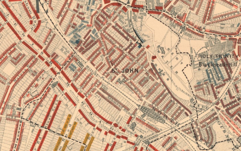
The conservation area is located between the centres of Deptford and Lewisham, adjacent to the railway line which runs between Lewisham and London Bridge. The area was developed in the mid-late 19th Century as the later southern part of Deptford New Town providing houses for Deptford’s expanding population. The residential streets were laid out on open land to the south of the Ravensbourne River and coincided with the opening of St. John’s Parish Church, the development of suburban railway lines and the opening of the local station at St. John’s.
Special Interest
The conservation area’s special interest lies in the cohesive character of the groups of buildings, expressed in terms of their architectural and historic features and the grid-iron layout of streets. Most buildings date from the 1850s-70s and are modest in size, usually two-storey two-bay terraced houses but some also have basements. Broadleaved trees line parts of the streets and this helps soften the regularity of the built environment. The conservation area also contains Brookmill Park situated to the south of the River Ravensbourne. This park was formerly part of the Kent Water Works. The conservation area covers approximately 10 hectares, contains 387 houses and has a population of over 1000 people.
Brookmill Park is the only part of the conservation area that is designated as an Area of Archaeological Priority. The riverside location may provide evidence of early settlement and later industrial archaeology.
18th Century Development
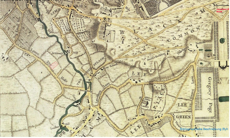
In the 18th century most of the area between the town of Deptford and the village of Lewisham was still open fields. The River Ravensbourne provided energy for a small number of mills. A water works had been established in 1701 at the present location of the Thames Water offices on Brookmill Road. (Now the site of the Stephen Lawrence Centre.) The 1744 map by John Rocque shows an area of market gardening to the south west of the water works as well as an armoury next to a mill on the River Ravensbourne. At this time Deptford was a long established town with an important maritime tradition and associated industries. The Royal Naval Dockyard had been established on Deptford Strand in 1513 by Henry VIII and this became England’s principal dockyard until Chatham took over in the 17th century. In 1742 the Navy Victualling Depot was established (renamed the Royal Victoria Victualling Yard in 1858) and this supplied the navy for over two centuries. During the late 18th and 19th centuries Deptford experienced commercial and industrial expansion as well as a large population increase. Between 1801 and 1901 the Parish of St. Pauls Deptford increased from 10,600 to 107,000.
19th Century Development
Deptford New Town was developed to the south west of Deptford Broadway during the 19th century and provided homes for Deptford’s expanding population and also residents commuting to London once the railways were established after the 1840s. The principal landowners in the area were the Evelyn and Lucas families. The Lucas family, like other local freeholders, had considerable commercial interests in the United States. On his return from the United States in 1823, Jonathan Lucas built Lucas Villa on Lewisham Way, which was used by the Welsh Presbyterian Church before becoming a nursery in recent years. Much of the housing in the conservation area was developed in the second half of the 19th century by another Jonathan Lucas after the land passed to him.
The 1843 Deptford Tithe Map clearly shows that the northern part of the New Town between Tanners Hill and Friendly Street was developed first. The New Town developed further east in the 1850s-70s during a period when railways encouraged suburban expansion of London. The North Kent Line opened in 1849 providing Lewisham and New Cross with a rail link to London Bridge, however St. John’s station did not open until 1873. The formation of the Anglican parish of St. John’s and construction of the gothic style church by Philip Hardwick in 1854 provided local impetus for development of the area. The Lucas family donated Lucas Villa and the surrounding area for the building of the church, another site for the building of St. John’s School on St. John’s Road (now Albyn Road). This was replaced by a new school in 1906, now known as St. Stephen’s School. The family also funded the building of the St. John’s Mission Hall in King Street.
The east side of Friendly Street was developed in the 1850s. St John’s Road (now Albyn Road), Admiral Street (formerly Seymour Street), Strickland Street and part of Cranbrook Road (Seymour Place) were developed by the time of the 1868 Ordnance Survey. The terraced houses on these streets are of superior architectural quality to many houses built elsewhere during this period and even to those which were developed later on in the New Town. This would seem to be because Lucas granted unusually long leases of 70 years. He was well aware that a short lease could lead to shoddy building. The rest of the streets in the conservation area were laid out over the next 20 years.
Infrastructure
While there is a uniformity of style and scale to the buildings and a regular street pattern, there is no evidence that this was seen as a planned development. The building surveyor’s returns indicate piecemeal construction involving a large number of small firms. It would seem that Lucas, partly through careful estate management and partly through his position as a local magistrate, kept a close eye over those streets already developed and ensured that the infrastructure, i.e. sewers and paved roads, was in place before new building began.
The Kent Water Works expanded to keep up with the demands of an increasing population and industry. It is shown in the 1868 Ordnance Survey as having five large reservoirs, which were supplied by wells sunk deep into the chalk strata below. Ravensbourne Farm is also shown but this and its accompanying land to the south east of Strickland Street was soon to be swallowed up by new development.
Bomb damage and origins of the park
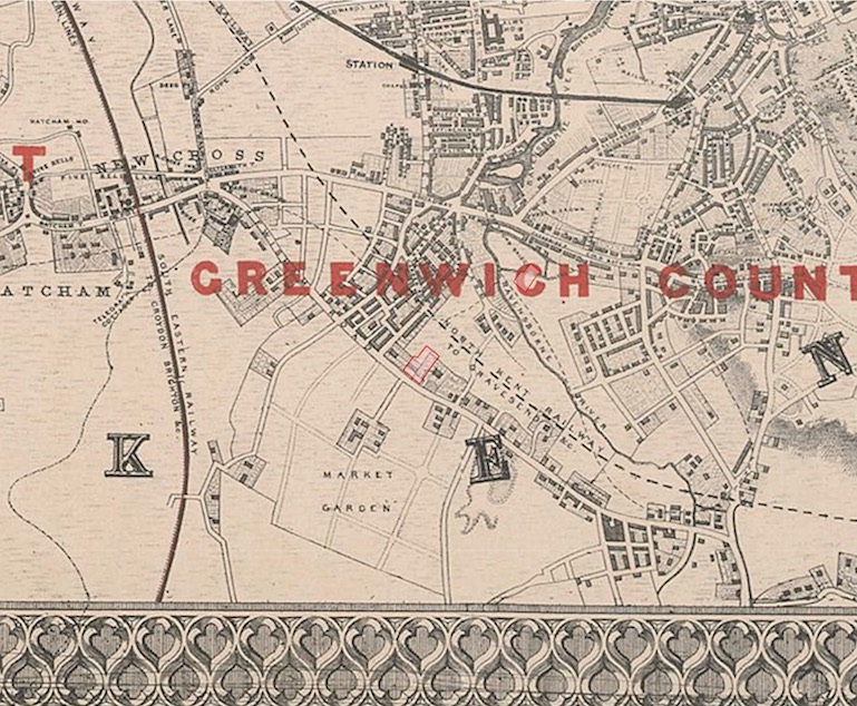
The 1894 Ordnance Survey shows Deptford New Town as completed after a century of development. It is interesting to note that the eastern side of Ravensbourne Road (now Brookmill Road) is built up with what looks like terraced houses. It is possible that these buildings suffered bomb damage during World War II as they seem to have been removed to make way for Ravensbourne Park (now Brookmill Park), which was opened in 1952.
20th Century Development and Demographics
By 1901 the population of the whole of the New Town had reached 10,000. Research drawn mostly from the census returns reveals that the New Town’s residents were from varied socio-economic backgrounds. These ranged from beggars and itinerant labourers, who occupied the numerous lodging houses in Mill Lane (first Ravensbourne Road, then Brookmill Road and outside the conservation area) to the semi-skilled and lower middle classes. ‘Labourer’ however would seem to be the most common description and seems to cover a multitude of occupations from unskilled to semi-skilled to the seasonally employed. It would seem that by the 1880s the older streets were occupied by labourers and the lesser skilled, while the newly developed streets were attracting the more skilled. There was only a very small number of skilled professionals and these lived in the substantial houses on Cliff Terrace, St. Johns Vale and Lewisham Way (all in the neighbouring St John’s Conservation Area). The census returns reveal that the majority of residents were born in Deptford or the surrounding parishes in Kent. Those residents that came from outside England came mostly from Ireland and were concentrated in the poorest areas, specifically the Mill Lane (Ravensbourne Road) lodging houses.
On the whole, the residents of the New Town enjoyed better living conditions with fewer persons per property than the Deptford and London average. The average number of persons per property in the New Town was 5.7 in 1851 and 6.1 in 1881, compared with the London averages of 7.7 in 1851 and 7.8 in 1881, and Booth’s figure of 6.8 for all of Deptford in 1891. Apart from Mill Lane (Ravensbourne Road) which was overcrowded, most of the houses in the lower middle class streets were in single family occupancy and many kept servants.
St John’s Church and local relief of poverty
The Reverend Canon CFI Money was the first vicar of the parish from 1855-83, and his evangelising manner gave the parish a distinctive protestant character. In 1856 Money estimated that 4,000 people in the parish were living in poverty and he established a ‘Visiting Society’ but made clear that assistance would be given to the deserving and indigent, and there would be no indiscriminate relief’. Up to the mid-1870s annual visits peaked at over 10,000, cash relief was given to up to 130, and relief was also given in the form of coal, food and blankets. Money also established a penny savings bank for those above the poverty line. The Methodists and the Roman Catholics also provided support to their members in need.
Although these efforts were both vigorous and well intentioned they did little to alleviate the problems of poor housing, public health or the root causes of poverty. These problems were tackled by the Greenwich Board of Works (GBW) and the London County Council (LCC). The Housing and Working Class Act 1890 gave authorities the power to demolish slums and redevelop the land for housing. The LCC wasted no time in demolishing 50 houses, including 8 lodging houses along Mill Lane (firstly, Ravensbourne Road now Brookmill Road). There seems to have been disagreement between the authorities over what form redevelopment should take. The LCC favoured a lodging house and the GBW, cottage style dwellings. A compromise was reached and in 1903 Carrington House was opened providing lodgings for 670 men and Sylva Cottages provided family accommodation. Even though these buildings are just outside the conservation area their significance in terms of social housing design can not be overstated.
More recent development
Large areas of the New Town to the north of Friendly Street were redeveloped in the 1960s following bomb damage during the Second World War. The streets that form the Brookmill Road Conservation Area survive remarkably intact, with only a small number of new houses, usually in a replica style, replacing earlier houses which were either bomb damaged or derelict. A considerable number of houses were acquired and restored by the Council during this period.
The houses built after 1840 in the eastern part of the area were generally of a better quality that those in the earlier streets. St John’s Church was built to serve the new suburb in 1855. The site was the garden of the old Lucas family house, which itself became the vicarage.
New Cross Gate and New Cross stations gave extra impetus in 1839 and 1850 respectively and the New Town estate was nearly completed before it got its own station, St John’s, in 1873.